From WikiGallery

Jump to: navigation, search
Share:        Link to this page
Jump to: navigation, search

Map of Britain and Ireland, 1595, published Antwerp 1624

by Abraham Ortelius

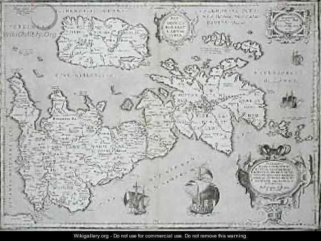
Map of Britain and Ireland, 1595, published Antwerp 1624 - Abraham Ortelius
[locked]

Information

Description
English: "Map of Britain and Ireland, 1595, published Antwerp 1624" oil on Canvas.
Source

http://www.wikigallery.org/

Date

1624

Author

Abraham Ortelius

Download

Click here to download image

Permission

Free for non commercial use. See below. Click here to report copyright issues.

Like it

[locked]

Licensing

Public domain This image (or other media file) is in the public domain because its copyright has expired. However - you may not use this image for commercial purposes and you may not alter the image or remove the WikiGallery watermark.

This applies to the United States, Canada, the European Union and those countries with a copyright term of life of the author plus 70 years.


Note that a few countries have copyright terms longer than 70 years: Mexico has 100 years, Colombia has 80 years, and Guatemala and Samoa have 75 years. This image may not be in the public domain in these countries, which moreover do not implement the rule of the shorter term. Côte d'Ivoire has a general copyright term of 99 years and Honduras has 75 years, but they do implement that rule of the shorter term.


[locked]

Rate this Painting

NOT RATED YET
Click on the stars
to rate this painting


[locked]

Next Paintings

Map of India to New Guinea, c.1570-1603 - Abraham Ortelius
Map of North and South America, from the Theatrum Orbis Terrarum, published Antwerp, c.1570 - Abraham Ortelius
Map of Palestine, from Theatrvm Orbis Terrarvm, 1570 - Abraham Ortelius
Map of the Kingdom of Valencia, from the Teatro de la Tierra Universel, 1588 - Abraham Ortelius
Map of the Middle East, from Theatrvm Orbis Terrarvm, 1570 - Abraham Ortelius
Map of the Pacific, China and America, 1589 by Abrahamus Ortelius l527-98 - Abraham Ortelius
Map of the World, from Theatrum Orbis Terrarum, Antwerp, 1598 - Abraham Ortelius
Map of Zeeland, c.1560 - Abraham Ortelius
Scotiae Tabula, 1580 - Abraham Ortelius
[locked]

Related Paintings

Illustration for a French edition of the Spanish Lazarillo de Tormes, 1801 - Pierre Nicolas Ransonette
Map of Great Britain Europe and North West Africa - Luis Lazaro
Tourists before a mausoleum - English School
By the Seashore - Addison Thomas Millar
Pique Nique Devant Le Golfe De Naples - Franz Richard Unterberger
Black Rock Castle, Dublin Bay - John Laporte
Vague et la Perle (The Wave and the Pearl) - Paul Jacques Aimé Baudry
Figures Coming Ashore in a Calm - Hermanus Jr. Koekkoek
A Fishing Village at Capri - Louis Gurlitt